


Trailforks
4.62.21K Reviews
App Specs
- Version
- 2026.8.0
- Updated On
- License
- Free
- Downloads
- 1,000,000+
- Developer
- Trailforks
- Categories
- Maps & Navigation
- Platform
- Android, iOS
Screenshots

 Analysis by AppCompare
When I’m choosing a trail app, I care less about having every possible outdoor feature and more about whether I can make a sensible route decision before I leave, then stay oriented when reception drops. Trailforks is built around mountain and biking trails, with maps, trail-status information, and reports from other users. That focus makes it especially appealing to riders who want local context, not just a line showing where to turn.
I’d think about how you actually spend time outside before installing it. If you regularly ride unfamiliar trails, check conditions before setting off, or plan outings with friends who know different areas, a trail-focused map can be more useful than a general navigation app. If you mostly need directions along roads or a simple record of a familiar walk, a broader maps app may be easier to live with.
A trail map is only as useful as the decisions it supports
On a practical ride, the useful question is not simply “Where does this path go?” It is whether the route suits your ability, whether recent reports suggest a problem, and whether you can find your way back if plans change. Trailforks brings trail information and community contributions into that planning process, which can help me choose a route with more confidence than a basic map view alone.
That extra context still needs judgement. A report reflects someone’s experience at a particular time; it is not a guarantee that conditions will be identical when you arrive. I’d treat recent community notes as clues to investigate, rather than as a promise that a trail is clear, safe, or suitable for every rider.
What is Trailforks All About?
Alright, let’s get down to business. Trailforks is essentially your go-to app for finding the best trails around you. Whether you’re a mountain biking enthusiast or someone who enjoys a leisurely hike, this app has got you covered. It’s like having a knowledgeable local guide right in your pocket.
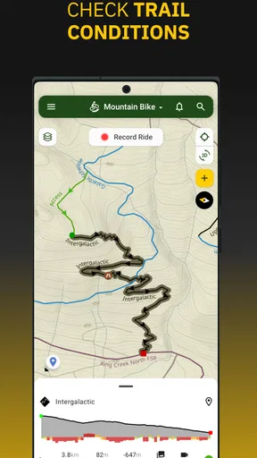
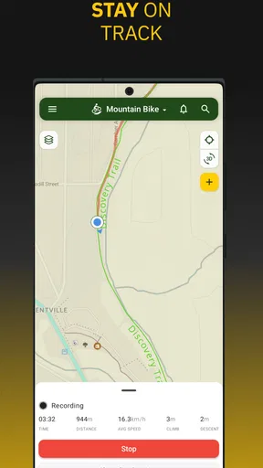
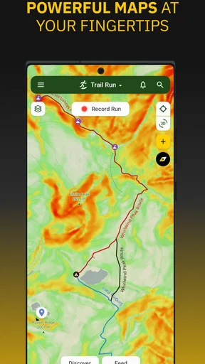
The app provides detailed maps and information about trails from all over the globe. And it’s not just about showing you where the trails are. You get to see trail conditions, user reviews, elevation charts, and even photos. It’s super comprehensive and makes planning your next outdoor adventure a breeze.
Getting Started with Trailforks
Setting up the app is straightforward. Once you download it from the Play Store or App Store, you just need to create an account or log in. The app then uses your location to show nearby trails, which is super handy when you’re already out and about.
Worth Reading Before You Choose

EA SPORTS FC Mobile 26 Is a Bigger Football Game, but It Takes Time

Flipboard Shows What News Apps Must Do Beyond the Feed

Switching to Android Auto Means Rethinking Your Driving Routine

Google Calendar Makes a Crowded Week Easier to Manage

Ludo King Makes the Most of the Minutes Between Plans

Baby Panda World Brings Quick Play to Modern Phones, but Its Game Library Feels Busy
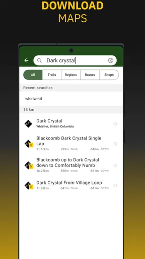
The interface is clean and intuitive. You can browse through different trails, filter them based on your preferences like difficulty level or type of activity, and even download offline maps. This feature is a lifesaver when you’re deep in the woods without cell reception.
Make offline preparation part of the route plan
I wouldn’t wait until the trailhead to think about offline access. Before leaving home, I’d look at the area I plan to ride, save the relevant map while I have a connection, and check that the route I expect to use is visible. That small routine matters because a downloaded map can help with orientation, but it doesn’t make every live feature available without service.
It’s also worth keeping the phone’s battery in mind. A long ride with the screen on for navigation can use power quickly, so I’d start with a charged device and avoid treating a phone map as my only safety plan. If I’m heading somewhere remote, I’d tell someone where I’m going and carry whatever backup equipment makes sense for the outing.
Features That Make Trailforks Stand Out
One of my favorite things about Trailforks is the community aspect. Users can contribute by adding new trails, reporting issues, or leaving reviews. This makes the app a dynamic platform constantly updated with fresh information. You can trust that the data is current and reliable.
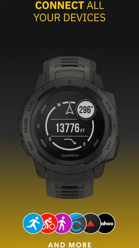
The app also integrates with GPS devices, which is fantastic for serious bikers and hikers who need precise navigation. And if you’re someone who loves to track your progress, the app offers features to log your rides or hikes. It’s pretty satisfying to look back at your trail history and see how far you’ve come!
Read reports as local clues, not guarantees
Community reports are most helpful when I use them to ask better questions. If a trail has a recent note about a blockage or a rough section, I can consider a different route or prepare for a slower ride. If reports are old or sparse, I wouldn’t assume that silence means ideal conditions. I’d use the map to understand my options, then make the final call based on the weather, my group, and what I see on the ground.
This is one of the app’s most valuable trade-offs: a community can surface details a generic map may not emphasize, but the information depends on people contributing. In a familiar, active riding area, that local input can be a real advantage. In a place with little recent activity, I’d lean more heavily on route knowledge and other dependable navigation resources.
The Social Aspect
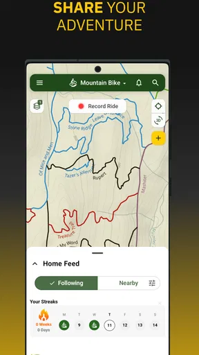
Another cool aspect is the social features. You can follow other users, share your favorite trails, and even compare stats. It’s like a social network for outdoorsy folks! Plus, you can get inspired by checking out trails others have explored and recommended.
For a group ride, I find the social layer most useful before the meetup: friends can point one another toward routes they know, and a shared trail choice gives everyone a clearer starting point for discussing difficulty and pace. It can also help a newer rider discover areas through people whose experience they trust. I’d still agree on the meeting place and route directly, rather than assume everyone will see the same information or updates at the same time.
Some Handy Tips
Here’s a little tip from my experience: always remember to download maps before you head out. You don’t want to be caught in the middle of nowhere with no signal. Also, take advantage of the user reviews. They often have nuggets of wisdom about trail conditions or hidden gems along the route.
Another thing to note is the weather information provided in the app. Checking the weather before setting out can save you from unexpected surprises, like getting caught in a sudden downpour. Trust me, it’s worth the extra minute.
Where it beats general maps—and where it doesn’t
Compared with the usual road-navigation apps, Trailforks is the more natural choice when the decision is about trails: finding a riding area, comparing route options, or checking community notes. A general map is often the simpler pick for driving to a trailhead, navigating city streets, or getting everyday directions. I’d happily use both for different parts of the same outing instead of expecting one tool to do everything equally well.
Dedicated activity trackers are another alternative. They can suit someone whose main goal is recording workouts or reviewing training, while Trailforks is more compelling when trail discovery and local trail context come first. The right choice depends on whether you want a catalogue of places to ride, turn-by-turn help, or detailed personal training analysis; those are related needs, but they are not interchangeable.
A realistic ride-day workflow
Imagine I have a free afternoon and a friend suggests a riding area I haven’t visited. I’d use Trailforks at home to inspect the available trails and reports, then choose an option that seems appropriate for the group rather than simply picking the longest-looking route. I’d save the map before driving out, check the weather, and agree on a meeting point and a sensible fallback if someone is tired or conditions are worse than expected.
At the trailhead, the map can help me confirm that I’m starting in the right place and keep the route in view. If the group changes its mind, I can look at nearby choices instead of improvising from memory. Afterward, the ride history and community features can help me remember what worked and share a useful recommendation. That’s a more grounded benefit than treating the app as a guarantee that every outing will go smoothly.
Who should choose it, and who should pass
I’d recommend giving it a look if mountain biking is a regular hobby, you travel to ride different areas, or you want trail-specific reports alongside your map. It can also be useful to hikers who explore trail networks and value knowing what other people have reported, though its strongest identity is around mountain and biking trails.
I’d skip it as my main navigation tool if I rarely leave paved routes, want a simple point-to-point road map, or have no interest in trail reports and community activity. It may also be less satisfying if you expect every remote route to have equally detailed, fresh contributions. In those cases, a general navigation app or a locally recommended map may be a better fit, and carrying a backup remains sensible for demanding trips.
Access, value, and the small switching costs
Trailforks is a free app from developer Trailforks, with optional in-app purchases priced from $10.99 to $89.90 per item. I’d start with the free experience and decide whether the way I use it justifies paying for anything, rather than assuming that every rider needs an upgrade. Its Teen content rating is also useful context for families deciding which apps belong on a younger rider’s phone.
Switching to it does not mean you need to abandon your existing map or activity tools. The practical cost is more about building a new habit: checking trail information before you go, saving offline coverage, and learning how its map fits into your ride routine. If you already rely on another app, try Trailforks on a familiar route first. That lets you judge its trail detail and interface without making your next unfamiliar outing depend on a tool you have barely used.
What to expect from continued use
The app has been available since August 4, 2015, and its current version is 2026.1.0. It has a 4.5 average from around 25,000 ratings, with over 1 million installs and about 2,100 written reviews. Those figures suggest an established audience, but they don’t tell me whether a particular trail near you has fresh reports; local usefulness still depends on the area and the contributions people make there.
For someone deciding whether to keep it, I’d judge it by a few outings rather than one quick browse. See whether the maps help you choose routes, whether the reports add practical context, and whether offline preparation feels manageable. If those things make your ride planning calmer, it has earned a place in your toolkit. If you mostly need ordinary directions or a training log, another category of app may serve you better.
Final Thoughts
All in all, Trailforks is a must-have app for anyone who loves the great outdoors. It’s packed with features that make exploring trails easier and more enjoyable. Whether you’re a solo adventurer or enjoy group outings, this app enhances your experience by providing all the information you need at your fingertips.
So, if you haven’t tried it yet, what are you waiting for? Download Trailforks and get ready to discover some amazing trails. Happy exploring!
Pros
- Extensive trail database worldwide.
- Offline maps for remote areas.
- User-friendly interface design.
- Real-time trail conditions updates.
- Community-driven reviews and photos.
Cons
- Limited features without subscription.
- Large app size can be storage-heavy.
- Some trails lack detailed info.
- Occasional GPS inaccuracies.
- No direct navigation feature.
FAQs for Trailforks
What is Trailforks and how does it benefit outdoor enthusiasts?
Trailforks is a comprehensive trail management system that provides detailed information about hiking, biking, and running trails worldwide. It offers real-time updates on trail conditions, user reviews, and GPS navigation. This app is beneficial for outdoor enthusiasts looking to explore new areas safely, with access to a vast database of trails and community-driven insights.
Is Trailforks available for both Android and iOS devices?
Yes, Trailforks is available for download on both Android and iOS platforms. The app is designed to provide a seamless experience across devices, ensuring that users can access trail information, maps, and other features regardless of their device choice. Simply visit the Google Play Store or Apple App Store to download the app.
Does Trailforks require an internet connection to function?
Trailforks primarily requires an internet connection for initial map downloads and updates. However, once maps are downloaded, the app can function offline, which is particularly useful in remote areas with limited connectivity. This feature allows users to navigate and access trail information without relying on mobile data.
What are the premium features available in Trailforks?
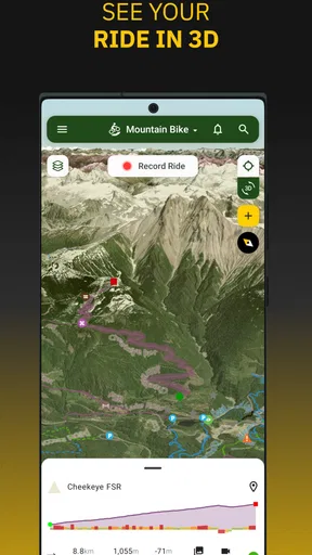
Trailforks offers a Pro version with premium features, including advanced map layers, offline mapping capabilities, and enhanced navigation tools. Users can also access detailed trail reports, 3D trail maps, and additional content not available in the free version. These features are designed to enhance the experience for avid trail users seeking more detailed information.
How does Trailforks ensure the accuracy of its trail data?
Trailforks relies on a community-driven approach for maintaining accurate and up-to-date trail information. Users can contribute by submitting trail reports, photos, and reviews. Additionally, partnerships with local trail associations and regular updates from app developers ensure that the data remains reliable and reflective of current trail conditions.


